Follow us on Telegram for the latest updates: https://t.me/mothershipsg
Intense heavy rain leads to floods. We get the basics of how floods happen.
In the past few weeks, overwhelmed canals and drains caused flooding on roads, creating hazardous situations for motorists, with some vehicles getting stuck in floodwaters.
Seasonal heavy rains are a regular occurrence in Singapore, so it makes sense that there have been regular upgrades to Singapore’s drainage systems over the years.
Should we expect floods every time the rainy season comes around?
To answer that, we first have to dive into how flash floods happen.
What are flash floods?
According to PUB, flash floods are episodes of localised flooding that typically subside within an hour.
They can happen during the monsoon season, and in the event of sudden heavy storms.
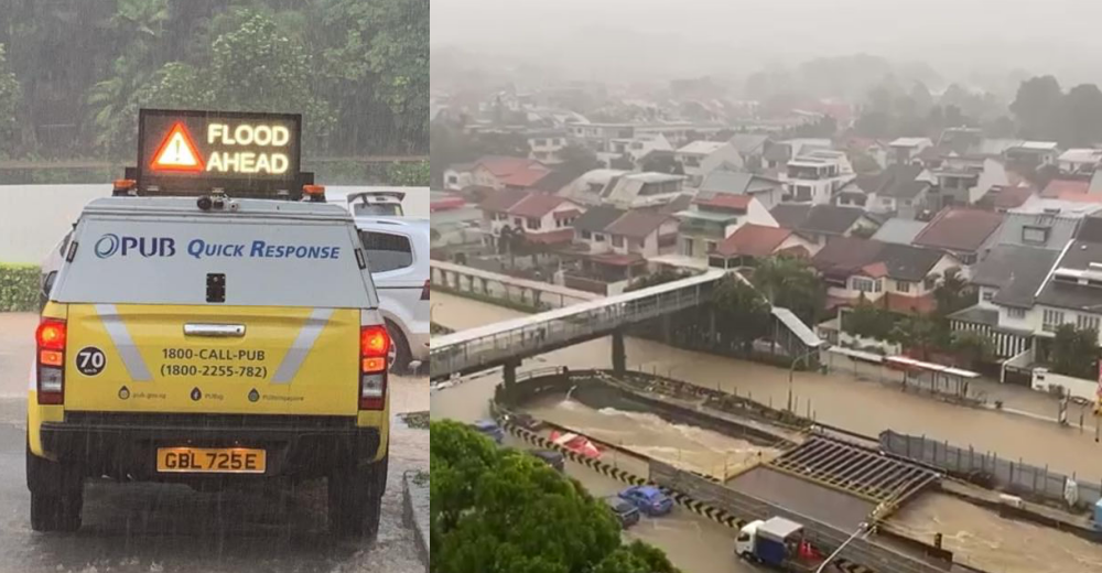
PUB has recorded five flash floods in this year alone, including two that happened just this month.
The most recent event on Tuesday (Aug. 24) coincided with unexpectedly high rainfall, with 159.8mm of rain collected between 7:50 am and 10:40 am, at the rainfall station at Bukit Panjang Road.
As PUB pointed out in a Facebook post on Aug. 24, this was 109 per cent of Singapore's average rainfall for the month of August, in just about three hours.
The rainfall on Aug. 24 was heaviest over the northern and western parts of the island with the highest daily total rainfall recorded of 239.8mm and 226.2mm at Mandai and Bukit Panjang respectively.
This surpassed the record highest daily total rainfall in August of 181.8mm at Changi, on Aug. 22 1983.
Flash flood at Bukit Timah on Aug. 24
The Bukit Timah area was especially affected by the downpour on Aug. 24.
Drivers, pedestrians, and residents in the area couldn't escape the flood.
Shortly before 10 am, PUB announced that water levels in drains and canals reached 90 per cent in Upper Bt Timah Road, from Hazel Park Terrace to Chestnut Drive, Woodlands Road, Sime Darby Centre, and Sunset Drive, and Sunset Way.
Moments later, they deemed the 350-metre stretch of Dunearn Road from Sime Darby to Binjai Park to be not passable, affecting all three lanes of the road.
The large canal in the middle of Bukit Timah Road and Dunearn Road was not able to contain the heavy rain, and the road lanes alongside it were submerged in floodwater.
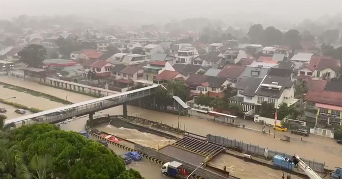 Flood along Bukit Timah Road. Image via SG Traffic Accident/FB.
There was a stream of slow-moving vehicles crawling along the adjacent roads.
And the heavy rain flooded housing estates in the area as well.
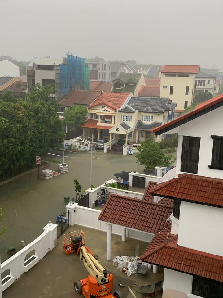 Housing estate in Bukit Timah. Image via Sim Ann/Facebook.
Looking at PUB’s list of flash floods since 2018, Dunearn Road has flooded twice this year, including the flash flood that occurred on July 12.
There was also a less-severe episode where rain was seen overflowing out of the storm drain in April, which PUB did not include in its list of flash floods.
And there have been seven flash floods in the area since 2018 — five along Dunearn Road and two along Bukit Timah Road.
Other locations like the Jurong East area (Jurong East Street 32 and Boon Lay Way) and Craig Road, have also had a number of flash floods in the past three years.
Some areas are just more flood-prone
PUB recognises certain areas as being more flood-prone.
These are low-lying regions with a history of flooding, and include Jalan Besar, Farrer Park, Stevens Road/ Balmoral Road and Chinatown.
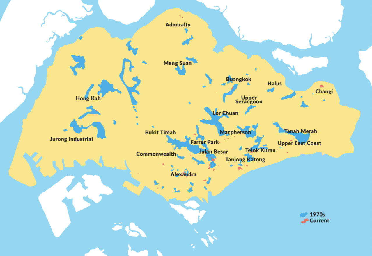 Map of flood-prone areas in the 1970s compared to now. Image via PUB.
However, the areas where recent flash floods were seen (i.e. Bukit Timah and Tampines) are not on this list.
Instead, some of the areas are considered hotspots — areas that are not low-lying but have experienced flash floods.
The list of hotspots on PUB's website is continually updated with new locations when flash floods occur and are removed when PUB has solved the flooding issues in the existing locations.
These issues include the drains being too small, roads that are sloping downwards, or even drains that need cleaning.
Often, PUB works with the relevant Town Council and other agencies on how to better manage these flood issues as well.
So, what exactly is done to prevent flooding in such areas?
The drainage system is prepped for floods
PUB adopts a ‘Source-Pathway-Receptor’ approach to achieve better flood protection.
This not only includes widening and deepening of drains and canals but also involves steps to slow down the flow of stormwater.
PUB also sets a minimum ground level for all proposed residential and commercial developments depending on their location and type of building.
And they also place flood barriers to prevent flood waters from entering buildings.
Here’s an infographic highlighting the different elements:
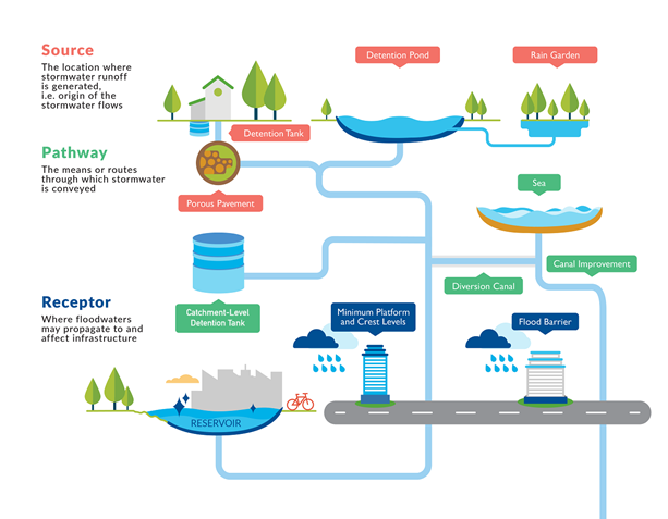 Image via PUB.
PUB stated that flood-prone areas have been reduced significantly from about 3,200 hectares in the 1970s to 28 hectares in 2020.
And with completed, ongoing and future drainage projects, Singapore no longer faces prolonged floods, as drains are generally able to cope with the rain that we receive.
Notably, between 2012 to 2019, a drastic transformation began, in the historically flood-prone Bukit Timah area.
Canals were deepened and widened, with additional tunnels constructed, allowing it to take in 30 per cent more rainwater along Bukit Timah Road (between Jalan Kampong Chantek and Maple Avenue) and Dunearn Road (between Swiss Club Road and Sixth Avenue).
PUB has continued its upgrading work in the area on the section of Bukit Timah Canal between Rifle Range Road and Jalan Kampong Chantek, where the recent flash flood occurred.
This work is expected to be completed in 2024.
In the meantime, as an interim measure, a 450-metre stretch of Dunearn Rd would undergo road raising works to mitigate flood risks, by Nov. this year, PUB announced on Aug. 28.
Despite these efforts, there are limits to what the drainage system can do in the event of exceptionally heavy rain.
Why do areas still flood?
Even with improvements in Singapore’s drainage system, PUB says that flash floods can occur for a number of reasons:
- Intense rainfalls in recent years are more than what the drainage system is designed to handle, hence, the large amount of stormwater within a short period can overwhelm the drains and overflow to adjacent areas.
- Localised depressions on the roads and on the ground are naturally prone to water accumulation.
- Clogged drainage systems where drains can get choked with leaves, litter, and other debris that get washed into them during storms.
While having larger drains and canals helps, there are limits to how wide drains can be, because of limited land.
Also, there are limits to digging deeper drains, especially in low-lying areas, as a minimum gradient is required for an effective flow of stormwater to the reservoirs.
“With climate change, we can expect to see a trend of more frequent and intense rainfall events. This could bring about more localised flash floods,” said PUB.
Even as PUB makes the necessary investments in infrastructure to cope with more volatile weather, it may not be possible to eliminate floods completely.
Managing the impact of flash floods
Instead, the impact of flash floods is managed in other ways.
PUB has worked on added measures to protect buildings, homes and those on the roads against floods.
They recommend that building owners add humps and flood barriers at the ground levels to protect their basement levels from floodwaters.
In an event of potential flooding, flood barriers can be raised either manually or automatically to prevent flood waters from flowing into the building.
Buildings can also link the water-level sensors in the basement carparks to their alarm systems in order to warn their users of flooding.
This is how flood barriers in front of buildings look like:
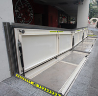 Flood barriers at Tanglin. Image via PUB.
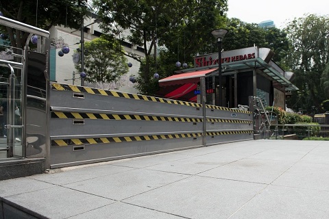 Flood barrier at Forum shopping mall. Image via PUB.
In addition, PUB has loaned portable barriers to residents at Upper Paya Lebar Road as an extra preventative measure against floods in flood prone housing estates, as part of a trial.
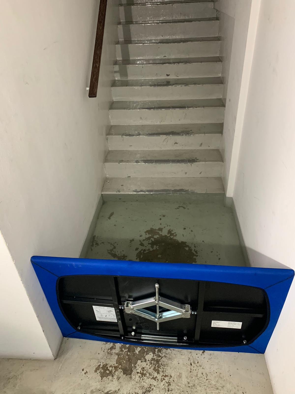 The Floodgate can be installed at doorways and entrances to block floodwaters. Image via PUB.
In flash flood situations, pedestrians, motorists, and residents are encouraged to exercise caution and keep updated on rising waters in drains and canals and potential flash floods via PUB’s Facebook or Twitter.
Follow and listen to our podcast here
Mothership Explains is a series where we dig deep into the important, interesting, and confusing going-ons in our world and try to, well, explain them.
This series aims to provide in-depth, easy-to-understand explanations to keep our readers up to date on not just what is going on in the world, but also the "why's".
Top image via PUB and SG Traffic Accident/FB.
If you like what you read, follow us on Facebook, Instagram, Twitter and Telegram to get the latest updates.