Singapore is currently in the middle of a tense territorial dispute in our seas with Malaysia over its sudden recent decision to expand its port limits into our territorial waters:
If you have no idea what the above means, you've come to the right place.
But first, what are port limits?
Port limits are the boundaries within which a country can conduct its sea port activities. These are usually within the boundary of a country's territorial waters, and may not necessarily be as large as our territorial waters.
And what are territorial waters?
Basically, waters that belong to a country.
So now that those two terms are defined clearly, let's dive into this dispute, best explained with a timeline:
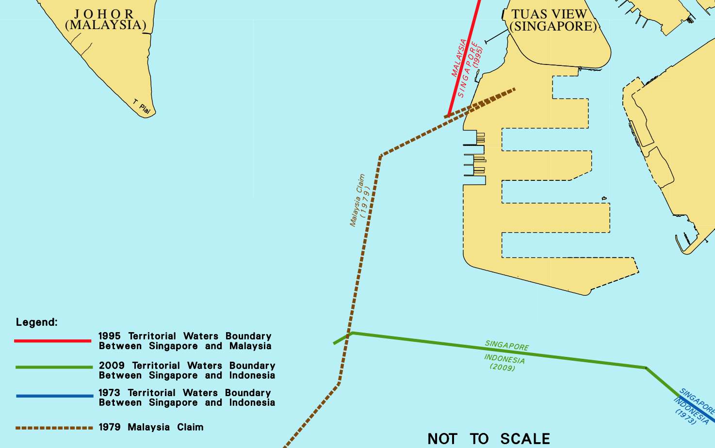
1979: Malaysia defines its sea territory in a map. Singapore says nope, but they don't care.
In that year, Malaysia published a map that extended the boundary lines of Malaysian territorial waters to both the east and west of Singapore, and intruded on Singapore's port limits.
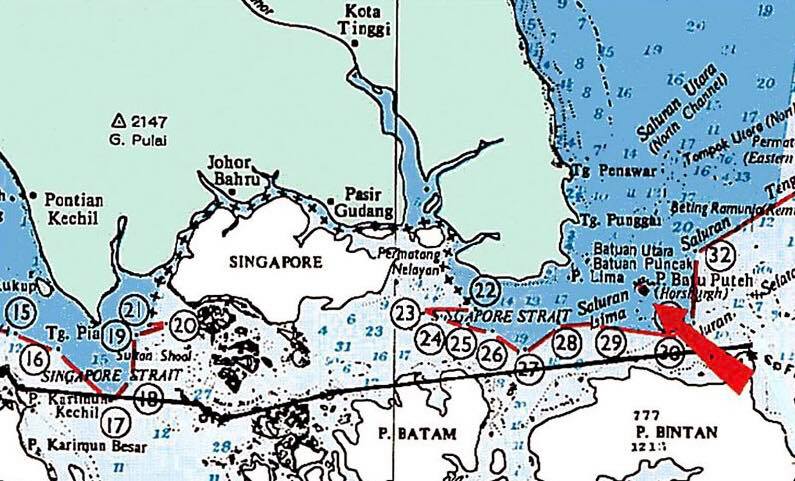
Pedra Branca (the black dot pointed to by the big red arrow in the map) is included in this territorial claim.
 Source: Alex Yam Facebook
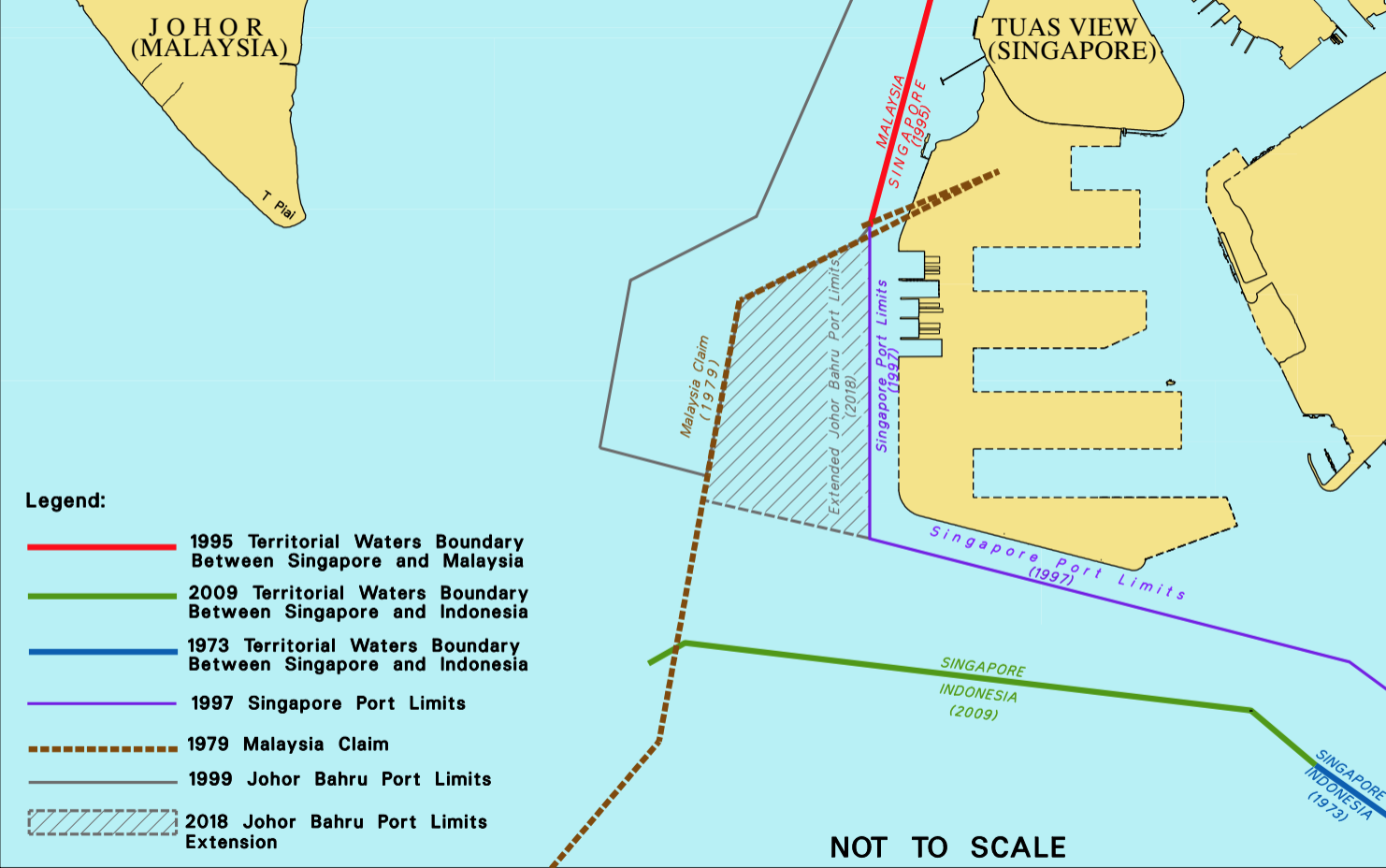
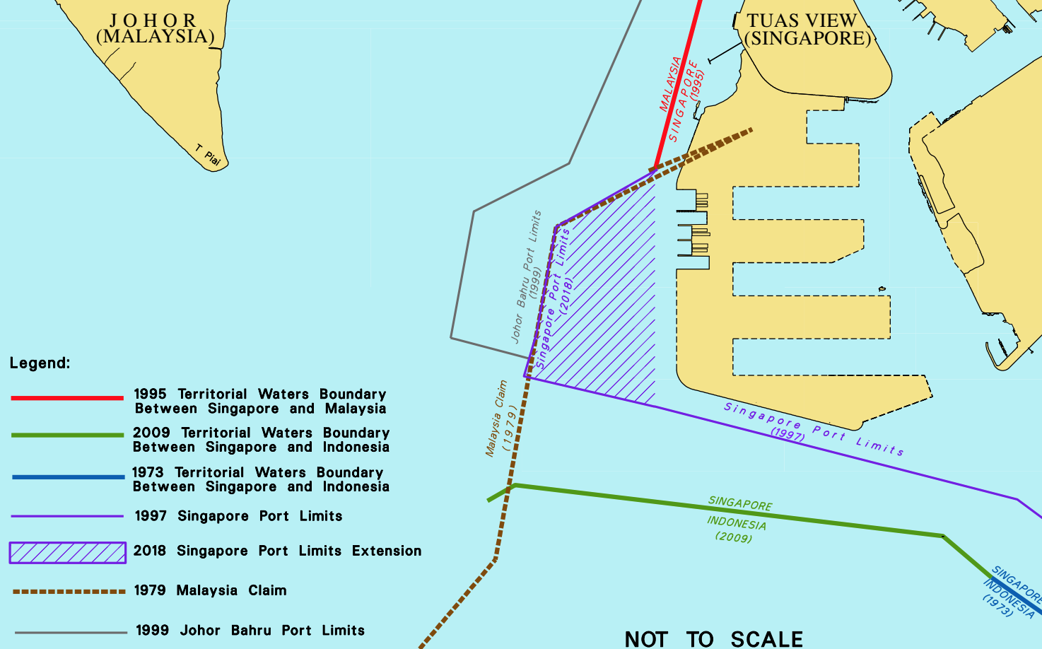
This map shows Malaysia's claim of the waters that belong to them — the dotted brown line, which, by the way, Singapore protested and didn't agree to.
The 1979 line cuts into modern day Tuas South.
 Source: Ministry of Transport
According to Transport Minister Khaw Boon Wan "these new boundary lines violated Singapore’s sovereignty and were unacceptable to Singapore."
The red line was the only agreed upon line between Singapore and Malaysia.
1980s
In 1980, Singapore formally protested with a diplomatic note requesting amendments to the map.
We patrolled our side (to the right of the dotted line) and protested any intrusions or unauthorised activities. Malaysia did not make any claims on the body of water we patrolled or protested our patrols.
Then, in 1987, Malaysia published its port limits, which matched the 1979 claimed boundary line.
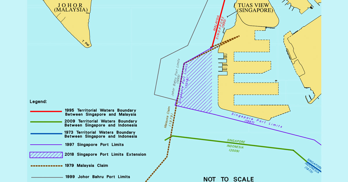
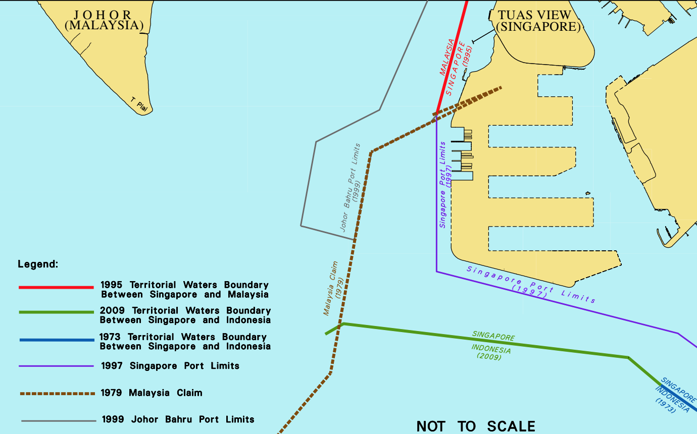
1997: Singapore defines our port limits, within our waters (according to the 1979 line)
Singapore set our port limits according to the purple line in the map below. Two years later, Malaysia redrew its port limit to the solid thin grey line in the same map, which was fine by us since it was still within Malaysian waters.
 Source: Ministry of Transport
So from 1999 till this year, everything was fine and dandy. The 1997 Singapore Port Limit (purple line) encompassed the Tuas South area as well.
Our navy and Police Coast Guard patrolled the waters belonging to us, the Malaysians didn't. We also made noise when people intruded our waters, and not once did Malaysia seem to have a problem with that.
Oct. 25, 2018: Malaysia unilaterally decides to expand its port limit into Singapore waters
Malaysia issued a federal government gazette called "Declaration of Alteration of Port Limits for Johore Bahru Port", which unilaterally and arbitrarily extended its port limit beyond its own territorial waters, into Singapore waters and right up to its port limit (the purple line):
 Source: Ministry of Transport
Between Nov. 24 and Dec. 5, Malaysian government vessels entered the grey shaded area, which is now disputed (because Malaysia decided to declare it was theirs, while Singapore said it should be Singapore's, as per the 1979 boundary they themselves had set).
Even as Khaw spoke to media on Thursday, Dec. 6, three Malaysian government vessels were still within the area.
These, according to the Ministry of Defence, include boats from the Malaysian Maritime Enforcement Agency, as well as the Malaysia Marine Department. One of these vessels lays buoys that mark territory in the sea.
Dec. 5: Malaysia uses Singapore's land reclamation as excuse to extend JB port limit
Malaysia issued a media statement claiming that Singapore has carried out land reclamation which does not extend Singapore's territorial waters.
And that Malaysia extending its port limit was well within their 'territory'.
In response to that, Khaw said that the new JB port limits extended beyond Malaysia's own territorial claim line it drew in 1979.
Dec. 6: Singapore extends our port limits to the 1979 boundary set by Malaysia as response
This would be the purple shaded area, a.k.a. the area Malaysia claims as its new port limit boundaries.
 Source: Ministry of Transport
The end.
Top image via Ministry of Transport
If you like what you read, follow us on Facebook, Instagram, Twitter and Telegram to get the latest updates.