Throughout the course of the mid-20th century, a network of expressways gradually bloomed across our city-state, becoming a ubiquitous feature of Singapore’s urban landscape.
Now, Singapore has more than 10 expressways and tunnels, with the North-South Corridor -- the longest transit priority corridor -- being the latest major road project that fulfils the evolving need of residents.
But our road networks weren’t always so sophisticated. And to understand how we even got here in the first place, we have to go back to the beginning -- a time before expressways existed in Singapore.All roads lead to the post office
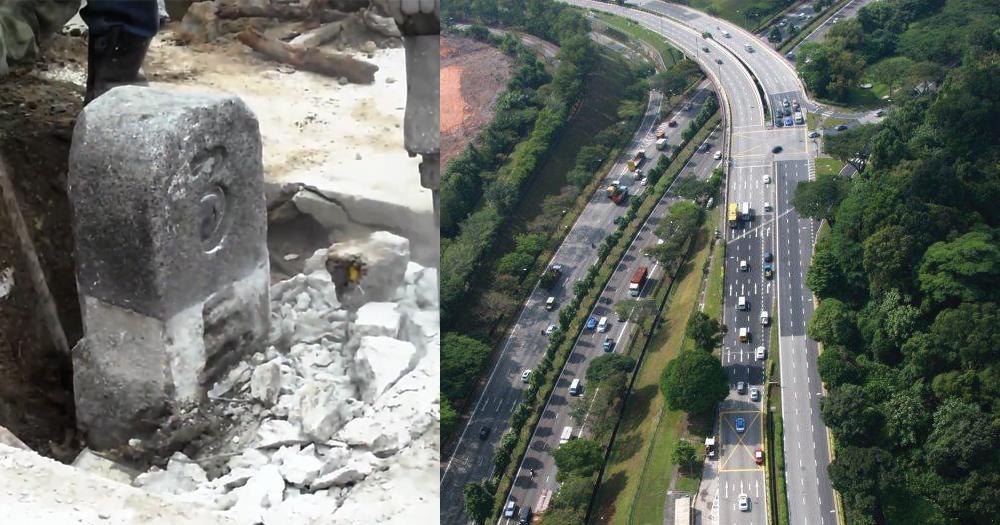
Up until the 1960s, the road network was made up of major trunk roads, including Bukit Timah Road, Upper Changi Road and Tampines Road, marked out by milestones.
Under this system, roads had granite milestones indicating how far it was from the General Post Office (today’s Fullerton Hotel), which was point zero from where main roads extended from.
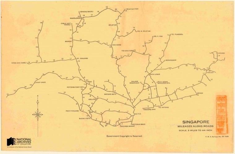 Photo via National Archives.
These roads would be populated with all sorts of motorised vehicles, including cars, trucks, buses and even lorry-buses.
Congestion was fast becoming a bigger problem on Singapore’s roads as the motor vehicle population had risen to nearly 200,000, Straits Times reported in 1966.
The beginning of expressways
To support higher volumes of motorised movement, the Pan-Island Expressway (PIE) was the first expressway to be constructed in Singapore, with its first phase of construction being completed in the late 1970s.
In 1981, the East Coast Parkway, a 19km expressway built on reclaimed land and over a water body, was completed.
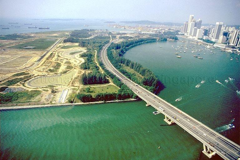 Photo via National Archives.
As part of the East Coast Parkway (ECP), the Benjamin Sheares bridge forms a wider urban planning mission to connect existing roads and highways to high-density satellite towns, while also serving as an efficient bypass that would take traffic around, not into, the city.
Between the 1980s and 1990s, six more expressways were built in what was known as the “Era of Expressways”, according to Biblio Asia.
This included the Bukit Timah Expressway (BKE), a six-lane dual carriageway serving housing estates in Woodlands, Bukit Panjang and Bukit Timah, the 26.5km Ayer Rajah Expressway, and the Central Expressway (CTE).
But it wasn’t as straightforward as just building long stretches of multi-lane roads without traffic lights.
Expressways in Singapore would also get more complex, with the 5km Marina Coastal Expressway (MCE) being an architectural marvel as it had a 420m stretch located under the seabed.
Evolving to serve other purposes
In the early years, roads and expressways supported urban development and ensured smooth traffic flow. As Singapore develops further, road projects will also need to evolve to meet the increasingly diverse travel needs of Singaporeans from all walks of life.
Looking into the future, the North-South Corridor (NSC) will be the latest example of how expressways in Singapore will increasingly support multiple nodes of transport.
The North-South Corridor: Singapore’s first integrated transit priority corridor
Even though originally conceptualised as an expressway, the evolving travel patterns of Singaporeans meant a return to the drawing board.
More Singaporeans are pursuing various possibilities of getting from one place to another, meaning that active mobility and riding public transport have become part of their way of life.
The NSC, which integrates different modes of travel, brings some good news for everyone.
Instead of an expressway merely serving vehicles, the 21.5km NSC will become Singapore’s longest transit priority corridor featuring continuous bus lanes, a cycling trunk route and pedestrian paths.
Additionally, the NSC will meet increased traffic needs arising from growing residential towns in the north, connecting towns such as Woodlands, Sembawang and Yishun to the city centre. With bus lanes and bus priority measures, travelling times to the city for bus commuters are expected to be reduced by 10 to 15 minutes during peak hours.
Active mobility users can also benefit from the cycling trunk route along the NSC, which links Park Connector Networks and dedicated cycling path networks within HDB towns to the city centre.
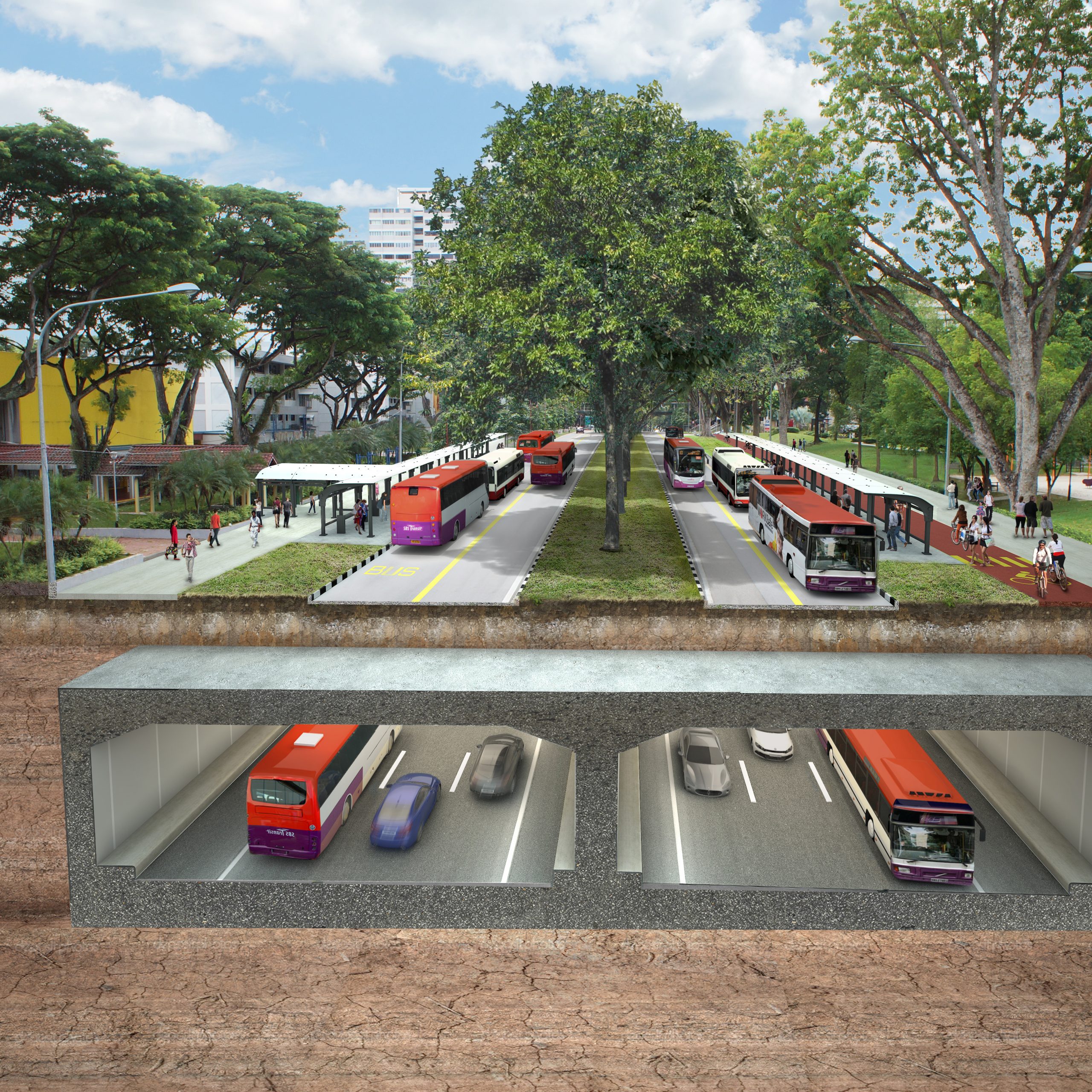 Photo via LTA
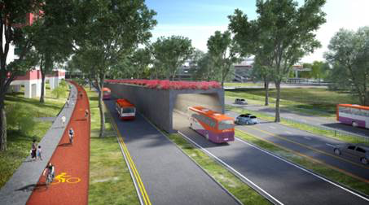 Photo via LTA
Basically, motorists and bus commuters will experience faster and smoother travel along this corridor, while pedestrians and active mobility users will benefit from a more connected infrastructure.
So how long would it take for someone to travel to the city?
Under the Land Transport Master Plan 2040 announced in 2019, the Land Transport Authority aims for nine in 10 peak-period Walk-Cycle-Ride journeys to be completed in under 45 minutes.
With roads adapting to support various visions of urban life in Singapore, the NSC is the next evolution. And the vision of a cleaner and greener land transport system for future generations doesn’t appear to be so far off after all.
Top photo credit: YouTube screengrab, photo by Mothership.
This is a sponsored article by LTA. Subscribe to LTA’s Telegram channel @LTASingapore for bite-sized news and happenings on Singapore’s land transport.
If you like what you read, follow us on Facebook, Instagram, Twitter and Telegram to get the latest updates.