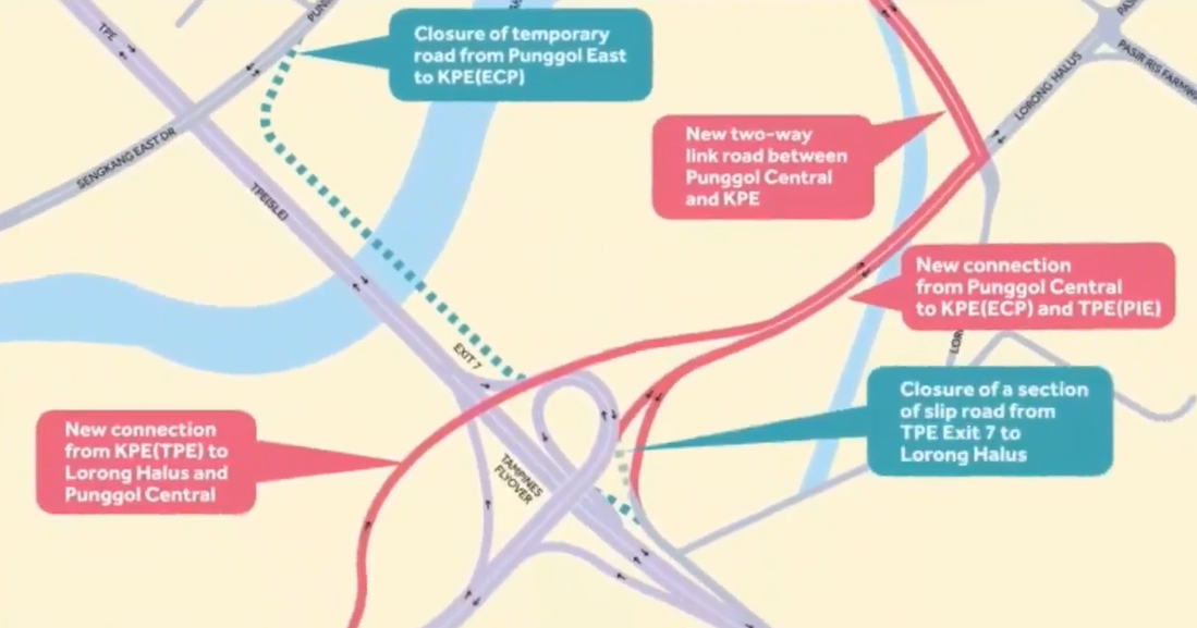
A new road linking Punggol Central to both the Kallang-Paya Lebar Expressway (KPE) and the Tampines Expressway (TPE) is opening on Nov. 25.
And some Punggol residents are confused about where it is.
This road was originally slated to open in the third quarter of 2019, but has been brought forward by one year.
Recent reports in the mainstream media have highlighted the transport woes of Punggol, as the estate has been growing at an unprecedented rate set to surpass the size of Ang Mo Kio.
Maps disseminated by the media and put online have shown where this new road is located.
But they tend to look like spaghetti sauce:

Directions to new road from Punggol Central to KPE, TPE
Therefore, for those who cannot read maps, this following video is a godsend:
It shows exactly how to get to the new road when exiting from and returning to Punggol -- with some CGI superimposed on the clip.
Punggol transport woes
Punggol currently has nearly 50,000 HDB flats.
This number is set to rise rapidly over the next few years.
HDB’s latest annual report showed that the number of dwelling units in Punggol will double to 96,000.
Over the past decade, the residential population in Punggol has almost tripled from 54,560 in 2008 to 161,570 as of June this year, based on data from the Singapore Department of Statistics.
Ang Mo Kio has a population of 165,710.
As Punggol morphs into one of the largest housing estates in Singapore with a slew of new developments, it is projected to be twice the size of Ang Mo Kio.
Until the new link road opens, Punggol has only three major arterial roads leading to the Tampines Expressway (TPE) and Kallang Expressway (KPE) -- Punggol Way, Punggol Road, Punggol East.
If you like what you read, follow us on Facebook, Instagram, Twitter and Telegram to get the latest updates.
