One man, Yin Shanyang, has created an interactive map of Singapore that visualises accessibility of any location by public transport.
These maps are called isochrone maps, and analysing its data tells us the most (and least) accessible locations to live in Singapore.
Fascinating.
What are isochrone maps?
If you are wondering what isochrones are, they are "akin to topographical contours, but instead of representing elevation they represent travel time."
In other words, isocrhone means a line on a diagram or map connecting points relating to the same time or equal times.
Isochrone maps that are colour-coded allows one to intuitively understand how far one can travel from a specific location within a certain amount of time by, say, using public transport .
Very nifty.
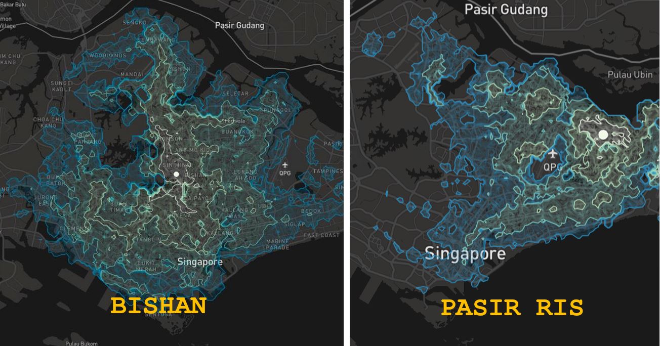
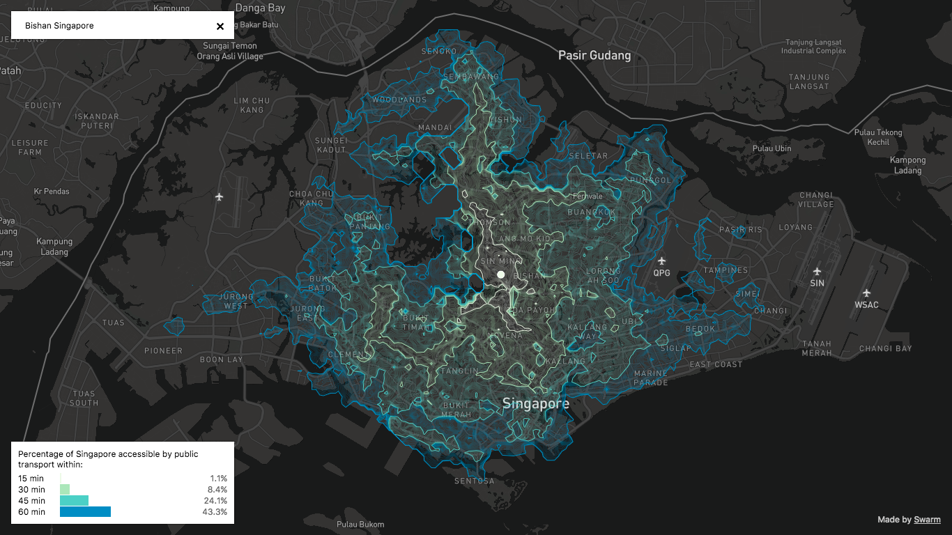
This is what the map for Bishan looks like:
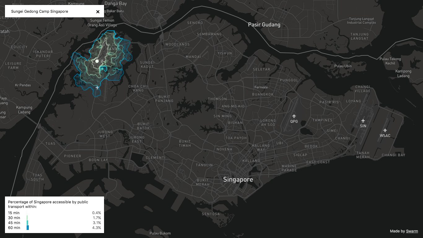
And just so you can see the contrast, this is what the map for Sungei Gedong camp looks like:
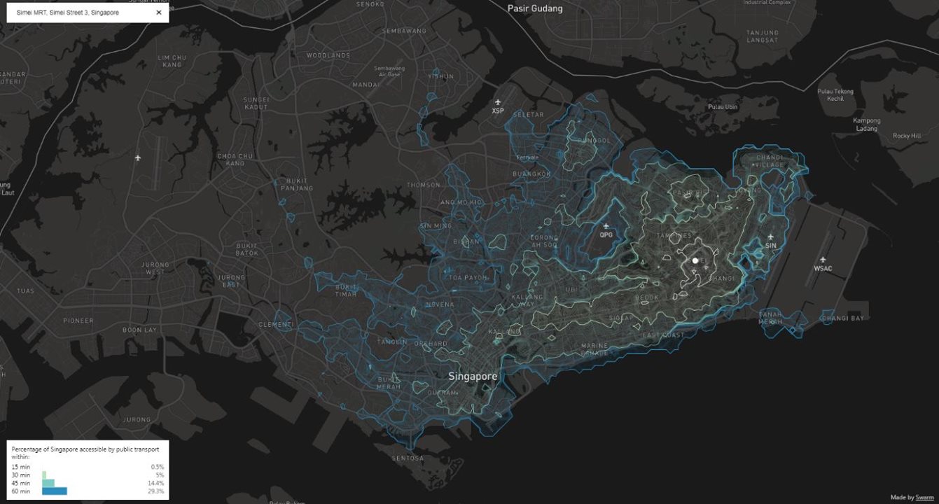
This is the map for Simei:
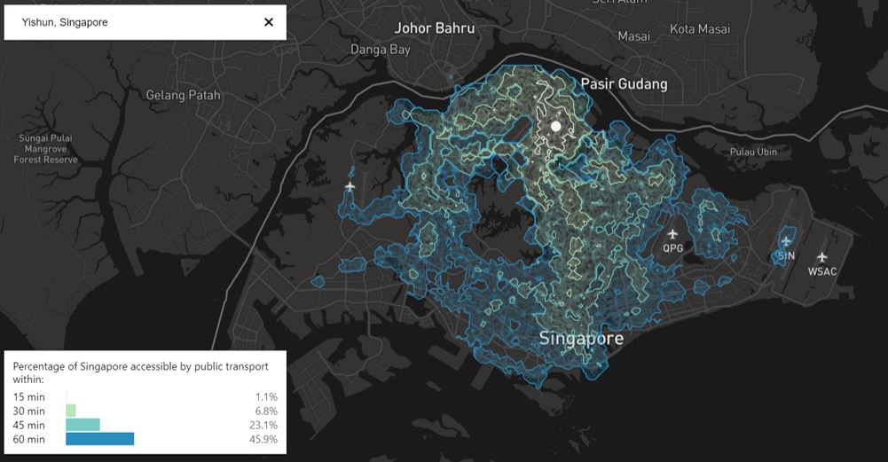
And this is Yishun:
Sorting the data
These maps provide great visualisations, but more can be done with the data collected. And this is where another person, Justin Zhou, comes in.
Using the data from these maps, he plotted it all in a giant excel spreadsheet.
He inserted the percentage values of how much ground one gets to cover within a given amount of time (15, 30, 45 or 60 minutes) from a certain location, and then sorted the values from highest to lowest.
In a Facebook note posted on April 7, Zhou shared his findings on the most and least accessible places in Singapore.
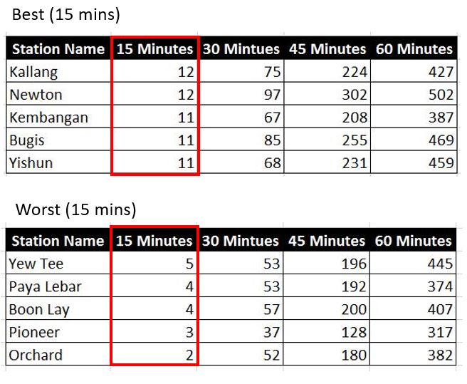
Travel time of 15 minutes
Sorting the values for the most and least ground you can cover within 15 minutes, which is a pretty fast commute, Kallang ties with Newton to rank first.
None of the MRT stations are in the CBD though, as others that have done well are Kembangan, Bugis and Yishun.
Interestingly, Orchard is the biggest loser in this category, along with Yew Tee, Paya Lebar, Boon Lay and Pioneer.
 Adapted from Justin Zhou's data.
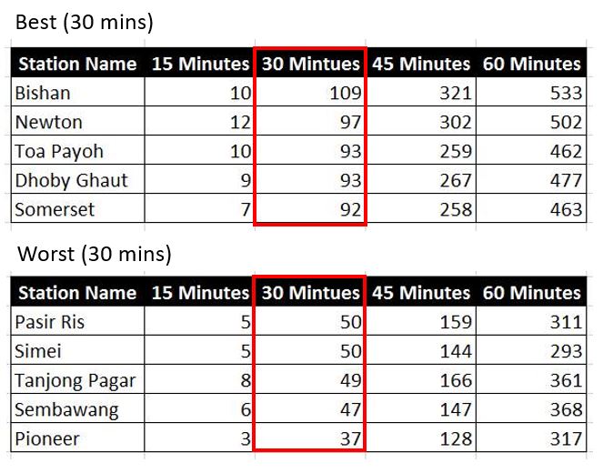
Travel time of 30 minutes
Within 30 minutes, you can cover the most ground from Bishan, Newton, Toa Payoh, Dhoby Ghaut and Somerset.
These are perhaps unsurprising, as Zhou pointed out that they have been "established as local transportational hubs."
He also mentioned that they are geographically in the center of Singapore, which allows one to cover more ground in every direction.
 Adapted from Justin Zhou's data.
The top losers for this category are Pasir Ris, Simei, Tanjong Pagar, Sembawang and Pioneer.
Within 30 minutes, one can barely cover 4 to 5 percent of Singapore.
[related_story]
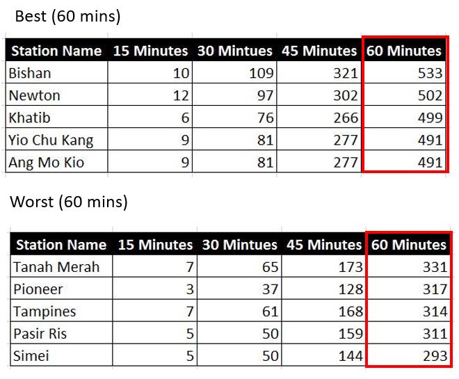
Travel time of 60 minutes
Within an hour (which is quite a fair amount of travel time), you can cover slightly over 50 percent of Singapore from Bishan. This is in comparison to Simei, which stands at a dismal 29.3 percent.
Three stations that ranked the worst, Simei, Pasir Ris and Tanah Merah, are also from the far east.
 Adapted from Justin Zhou's data.
Given all these findings, Zhou concluded that Bishan is the most accessible place to live, and Pioneer is pretty inaccessible.
"Bishan’s a really good place to stay if you’re very sociable and like to meet friends around the island. Pioneer consistently is in the bottom 5 in every category."
All isochrone maps, including top photo, from Isochronic Singapore created by Yin Shanyang
If you like what you read, follow us on Facebook, Instagram, Twitter and Telegram to get the latest updates.