In what seems like the oddest-yet government initiative, MRT system maps now include a bit of information we never knew we would need: walking time between stations.
Because these days, if you're caught in a train disruption, the best thing to do, especially if you're in the town area, is to walk.
And burn 4.5 calories per minute you spend walking.
But before we get to the part where everyone gets triggered, let's tell you a bit about it first.
The new Walking Train Map
Rolled out on Tuesday, Sep. 12, the new network map, also called the Walking Train Map (WTM), was progressively put up at 19 MRT stations, including Bugis, City Hall, Chinatown, Dhoby Ghaut, Esplanade, Little India and Raffles Place.
Here's a snapshot of the stations that show walking times between them:
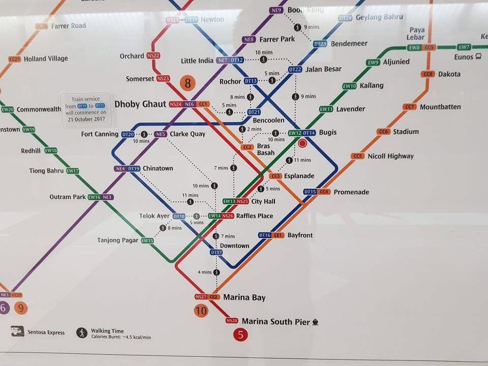 Image via SGTrain's FB
And please also note the footnote that adds the apparently-useful detail that you stand to burn 4.5 calories for each minute you spend walking.
By deriving timings through walking trials conducted based on Singaporeans' average walking speed, the Land Transport Authority (LTA) says the map will help commuters "decide if they prefer to walk and save time on their commute".
There are reportedly 18 of these hacks found on the map, with one of them being the distance taken from Telok Ayer MRT station to Raffles Place MRT station.
It is estimated that by train, travelling time between the two stations, for instance, is about 23 minutes because of line transfers. However, if a commuter chooses to walk, the estimated travel time between the two stations is just five minutes. And 22.5 calories burnt.
The Straits Times and The New Paper reported that this map "will also come in handy during train disruptions, serving as alternative routes for commuters".
[related_story]

Naturally, many were triggered
In no specific order, here are some good reasons raised by disagreeing netizens:
1. Total transport fare may still be costly
"Walk between stations but you will incurr more travelling cost. LTA does not allow people to take more than 1 train ride per journey. The moment u tap out of the station and enter again it will be consider as a new journey and you will be charged all over again."
2. Inconvenient and possibly unnecessary
"My goodness. How useful is the information to the old, pregnant and handicapped? This must be another bright scholar's idea."
"Try walking from Tuas Link to Pasir Ris."
"Hello! Google Map already can tell what is the walking distance. Don't waste taxpayers money!"
3. The irony of it all
"Hahaha imagine the meeting they had to come up with this: 'how can we solve the train breakdown issue' 'uhhh they can walk...?'"
"Taking MRT is supposed to save time from walking, not the other way round."
"This shows u build so many stations near one another for what.... you are wasting taxpayers' money."
"This is to prepare for more breakdowns for sure. They have no confidence in the trains themselves."
(All screenshots via The Straits Times' post and The New Paper's post)
LTA, thankfully, has said it will study public reception and feedback to the new maps.
It will also look into providing detailed walking directions between the MRT stations, as well as the "feasibility of expanding this initiative".
So if you've anything to add to this list of complaints, or perhaps any compliments for it, here's your opportunity — you can provide feedback via any of these channels.
But hey, in other news, this map might just come in handy during the current F1 road closures too, right?
Top image via SGTrain's FB

If you like what you read, follow us on Facebook, Instagram, Twitter and Telegram to get the latest updates.