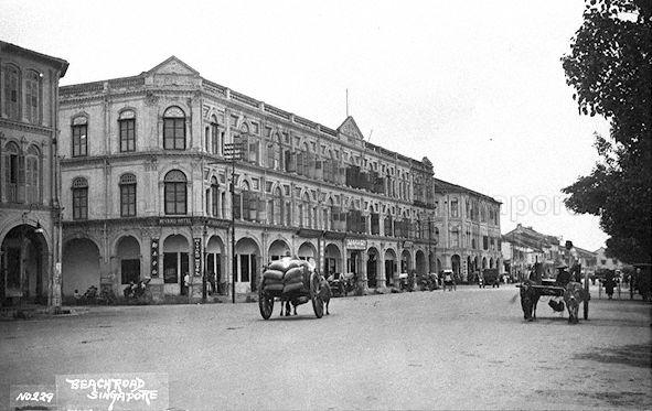
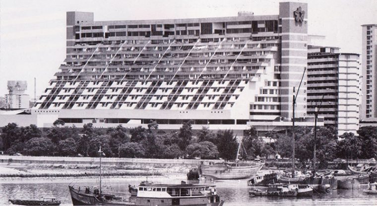
Ever wondered why Beach Road is named after a seemingly non-existent beach?
That is because Beach Road used to run along our original coast - as seen in the 1836 Map Of The Town And Environs Of Singapore.
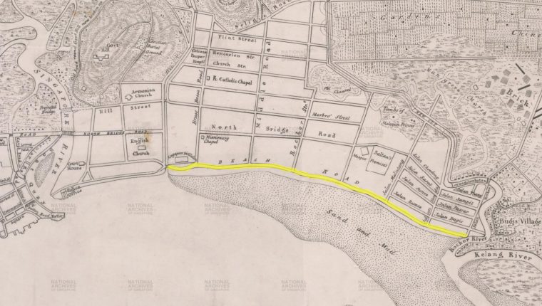 Taken from National Archives.
The road (highlighted in yellow above) ran along a coast that consisted of swamp land, sand, and mud.
From the 1840s onwards, land reclamation work began along Beach Road's coastal area.
Over time, the reclaimed land gave us Nicoll Highway, Suntec City, and the Esplanade.
There were many other names for Beach Road in the past. In Tamil, the road was called Kadal Karat Sadakku, which translates into "Seaside Road". In Hokkien, one of its names was Sio Po Hai Ki which means "Small Town Sea Shore".
Small Town (Xiao Po) was the locals' reference to the side of the Singapore River, where City Hall and Beach Road are. The opposite side of the Singapore River was called Big Town (Da Po) and that covered Raffles Place, Chinatown, and Telok Ayer.
Here are some interesting facts about Beach Road:
Beach Road was reserved for a European Town under the Raffles Town Plan
Much of Beach Road ran along the European Town, as stipulated under the Raffles Town Plan, before extending into Kampong Glam.
The Town Plan was drawn up by British Lieutenant Philip Jackson as part of Raffles' vision for a tidy Singapore town, where the Chinese, Malays, Indians and Europeans would live in separate quarters. However, the plan was never fully executed.
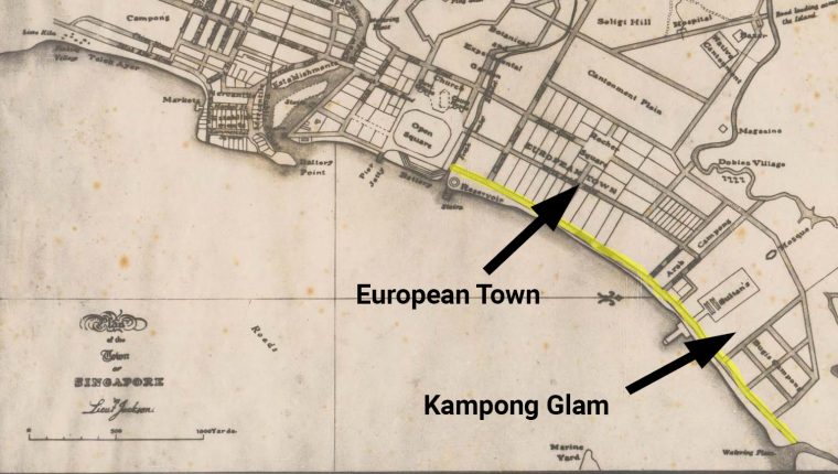 Adapted from Raffles Town Plan picture from Wikipedia. Beach Road is highlighted in yellow.
There used to be beachfront residences along Beach Road
As part of the European Town, Beach Road was home to many early European houses. At least 20 houses, each with a spacious garden, used to dominate Beach Road, leading the people to name the road ji chap keng in Hokkien, literally translated as "20 Houses".
The inhabitants of these homes were no ordinary Toms, Dicks or Harrys. They were William H. Read (Read Bridge), John Purvis (Purvis Street), and D. S. Napier (Napier Road).
In the 1970s, a more modern beachfront residence along Beach Road in the form of Golden Mile Complex was constructed. Back then, the apartment complex was promoted as “luxurious flats and penthouses” with a seafront views, as seen in the picture below.
Beachfront residences along Beach Road were extremely popular among the rich in the past, but the area's popularity declined because land reclamation removed the beach out of Beach Road.
Raffles Hotel
Interestingly, Raffles Hotel had its origins in a house along Beach Road. Originally named Beach House (duh), the building changed numerous hands before ending up as a property owned by four Armenian brothers known as the Sarkies. The brothers expanded the premise with new wings and added new suites to the hotel.
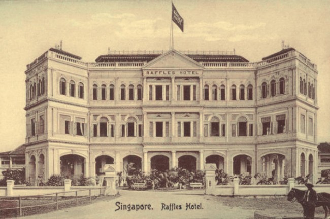 Raffles Hotel. Source.
Beach Road is also a Little Hainan
With the exodus of residents away from Beach Road due to land reclamation over time, Beach Road transformed into a favoured enclave for Hainanese immigrants. Even in the present day, there are remnants of Hainanese influences in the area. For one, the Singapore Hainan Association is located along 47 Beach Road.
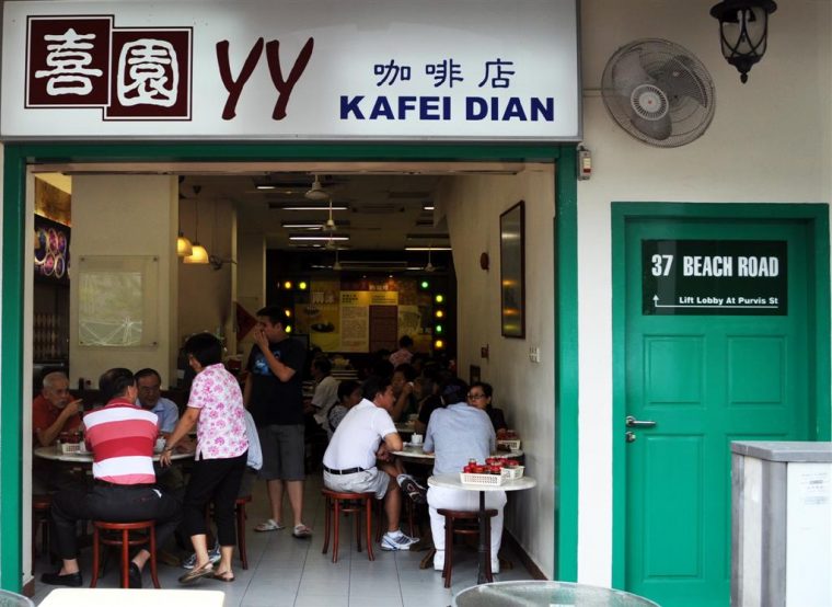 Hainanese fare along Beach Road. Source.
Hainanese food is also commonly associated with the Beach Road area. Some of the well-known eateries include YY Coffee Shop (for kaya buns and traditional Hainanese desserts), Chin Chin Eating House (chicken rice), and Prince Coffee House (fusion Hainanese Western food).
Beach Road had two cinemas
Way before Shaw Tower stood along Beach Road, there were not one, but two cinemas which served the area. They were the Alhambra and Marlborough.
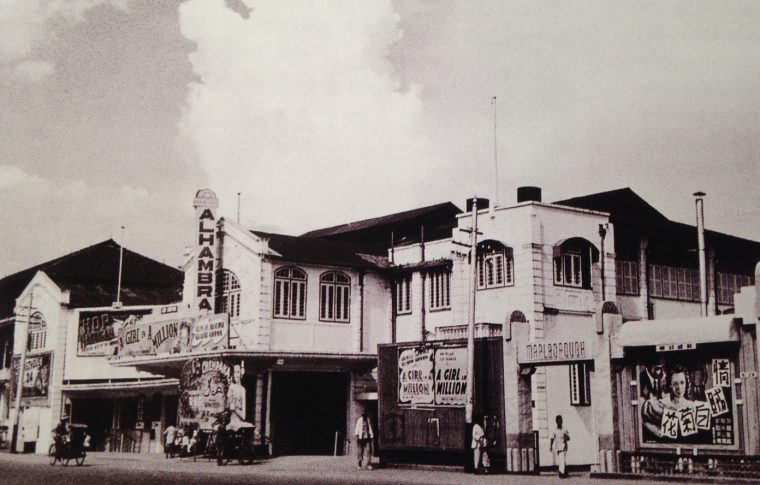 The Alhambra (left) and Marlborough (right). Source.
What made the Alhambra cinema special was that patrons could hear the sounds of the sea and creaky boats as they were watching the movies. The tide would also crash against the outside of the cinema walls!
Additionally, the cinema always had a group of musicians who played live music.
Top photo from NAS
Related article:
Why is Singapore’s Waterloo Street also known as “Si Beh Lor”?
If you like what you read, follow us on Facebook and Twitter to get the latest updates.
If you like what you read, follow us on Facebook, Instagram, Twitter and Telegram to get the latest updates.
