
Follow us on Telegram for the latest updates: https://t.me/mothershipsg
On Sep. 3, over 105,000 residents in the Miyokajima and Ishigaki cities of the Okinawa prefecture were ordered to evacuate as the strongest typhoon so far this year churned past the island chain south of mainland Japan, NHK reported.
Japan Airlines said on Saturday (Sep. 3) that it cancelled 56 flights, affecting about 3,230 passengers, Bloomberg wrote.
ANA Holdings also canceled 44 flights on Saturday (Sep. 3) and 22 scheduled for Sunday (Sep. 4).
Typhoon Hinnamnor is the strongest typhoon recorded this year, and was heading north over Okinawa waters on Sep. 3.
On Aug. 30, Hinnamnor recorded wind speeds of up to 260kmh, according to NASA.
 Typhoon Hinnamnor from Space. Image via NASA.
Power outages reported in Taiwan
As of 5pm on Sep. 4, Japan's Meteorological Agency classified Hinnamnor as a "Very Strong Typhoon", with wind gust speeds of up to an estimated 219kmh.
Moving at a slow speed of 20kmh, stormy conditions brought by the typhoon are expected to last hours, NHK noted.
The typhoon is forecast to continue to bring strong winds and rainfall to the Kyushu prefecture in Japan from Monday (Sep. 5) to Tuesday (Sep. 6), NHK reported.
Taiwan's Central News Agency reported that 60,000 households in the New Taipei, Taoyuan and Hsinchu counties experienced power lost due to the typhoon damage, although power has been restored to most households by 5pm on Sunday (Sep. 4).
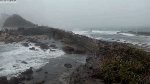 Yehliu National Park, north of Taiwan at 6am on Sep. 4. Video via Skyline Webcams.
 Landslides along roads in Hsinchu county, Taiwan. Image via TTV News/Youtube.
China and South Korea bracing for impact
Forecasts now expect the typhoon to head further north-east over the next few days, with above-average sea surface temperatures helping to sustain and strengthen it, NASA wrote.
China's State Flood Control and Drought Relief Headquarters expects Typhoon Hinnamnor to brush the coast in the Zhejiang and Jiangsu province, according to state news agency Xinhua.
It has set emergency response teams to these areas in anticipation of typhoon response and relief work.
The Korean Meteorological Administration expects Hinnamnor to approach the Korean peninsula as early as Monday morning, Sep. 5, with wind speeds of up to 54ms, or around 190kmh.
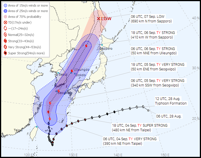 Image via Korean Meteorological Administration.
It has warned that Typhoon Hinnamnor could be one of the most destructive typhoons ever to hit the country, Bloomberg wrote.
South China Morning Post reported Woo Jin Kyu, a weather analyst from the Korean Meteorological Administration, saying:
“We’ve never encountered a typhoon with this level of atmospheric pressure before, which is extremely worrisome because the degree of damage may be beyond our expectation.”
The Korean Herald reported that weather advisories were issued in the southern parts of Korea, including cities of Gwangju, Busan, Daegu and Ulsan on Sep. 4.
An advisory was issued for Jeju Island on Sep. 3.
100mm to 300mm of rain is expected across the country, with Jeju island receiving as much as 600mm of rain, The Korean Herald wrote.
Classes were also ordered by the South Korean government to be cancelled or switched to an online format until Tuesday (Sep. 6).
You can track the movement and size of Typhoon Hinnamnor here.
Top image via Lam Yik Fei/Getty Images
If you like what you read, follow us on Facebook, Instagram, Twitter and Telegram to get the latest updates.