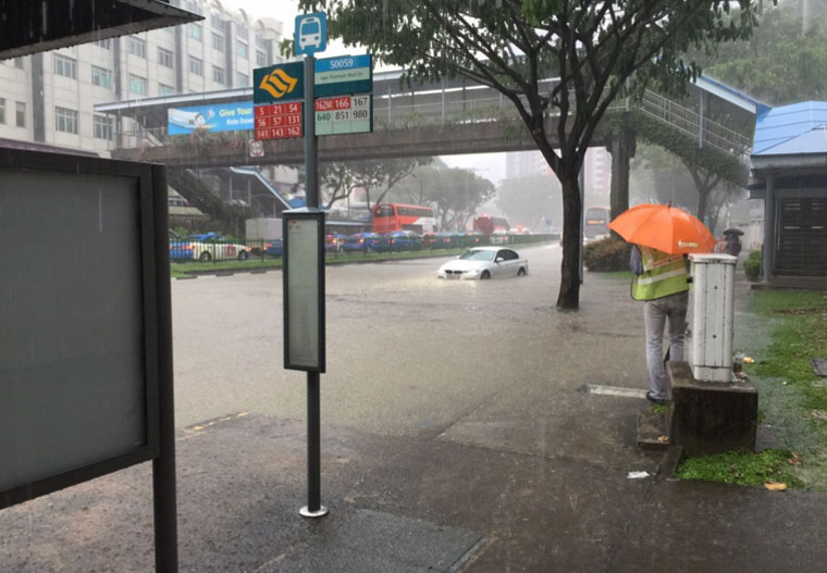
Heavy rains caused flash floods in several areas in Singapore on Friday, Dec. 11 afternoon.
The Public Utilities Board sent out an alert at about 1.25pm on its Twitter account that there were flash floods at Thomson Road but traffic was passable.
As the heavy rain subsided, PUB issued a warning cancel at 2.27pm.
Almost all the flash floods were cleared by 2.50pm.
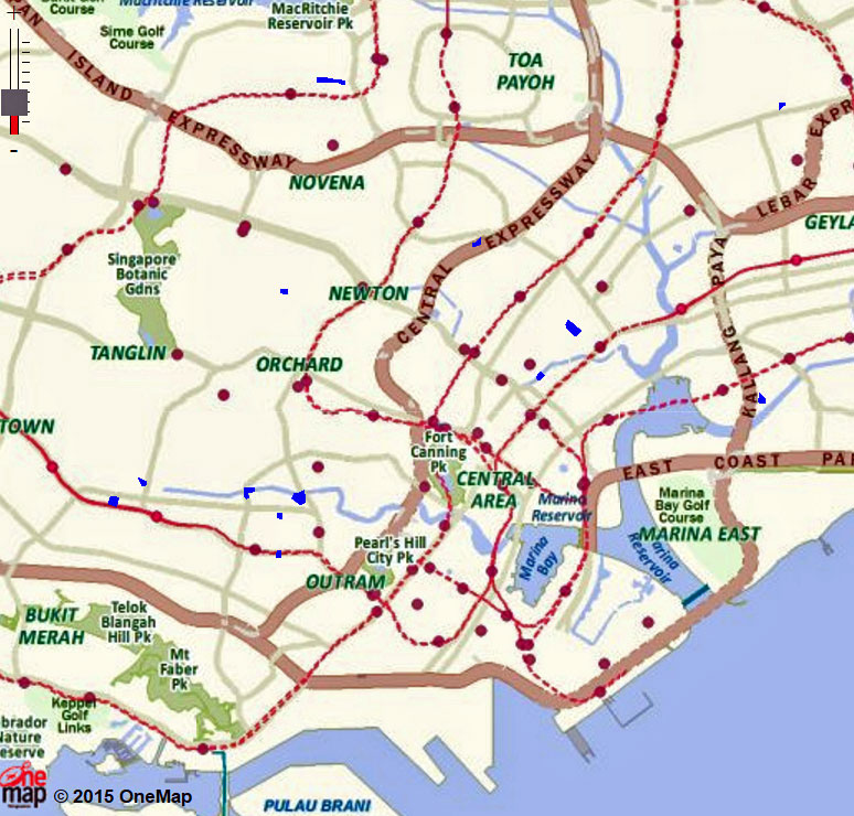
Instead of following the news all the time and wondering why is Singapore flooded, the public can get more information on PUB's website about where flood prone areas lie in Singapore because these will most likely be the places that will end up in flood-related news.
According to PUB's definition, flood prone areas are those areas which are low-lying, with a history of flooding.
Hotspots, on the other hand, are areas which are not low-lying but had experienced flash flood.
PUB's achievement over the years has been the reduction of flood prone areas in Singapore from about 3,200 hectares in the 1970s to 34 hectares today, as there are and have been numerous ongoing drainage improvement works.
Here is a list of flood prone areas:
1. Hong Kah area
2. Second Chin Bee Road
3. Commonwealth Ave / Commonwealth Drive / Queensway
4. Jalan Mat Jambol
5. Neo Pee Teck Lane/ Pasir Panjang
6. Admiralty Road West near Sembawang shipyard
7. Clover Park Estate
8. Marymount Lane / Marymount Road
9. Jalan Taman
10. Stevens Rd/Balmoral Rd
11. Farrer Park Area (including Thomson Road / Derbyshire Road) / Farrer Park Field
12. Waterloo St / Albert St / Bencoolen St / Prinsep Street
13. Jalan Besar Area
14. King George's Avenue (People's Association HQ)
15. CTE near Slip Road to Moulmein Road
16. Arab St/Rochor Canal
17. Jalan Mashor
18. Delta Road/ River Valley Road/Delta Avenue
19. Alexandra Road / Jervois Road/ Bishopsgate Road
20. Lower Delta Road / Alexandra Road
21. Leng Kee Road
22. Beach Road
23. Margaret Drive/Tanglin Road
24. Viking Road
25. South Bridge Rd/North Canal Rd/Upp Hokien St/Upp Pickering St
26. Indus Road
27. Kim Tian Road/Tiong Bahru Road
28. Zion Rd (Boys' Brigade HQ)
29. Delta Ave (APSN Delta Senior School)
30. Langsat Road Area
31. Rose Lane
32. Sennett Estate (Puay Hee Ave, Siang Kuang Ave, Wan Tho Ave, Jln Kemboja, Mulberry Ave and Jln Wangi)
33. Meyer Road / Fort Road / Arthur Road / Margate Road / Ramsgate Road
34. Jalan Seaview/Tanjong Katong Rd South
35. Jalan Gembira
36. Jalan Benaan Kapal
37. Service road off Tampines Road (near Jalan Teliti)
38. Lorong Buangkok
39. Mimosa Walk
40. Mindef’s Changi Camp off Farnborough Road
41. Bedok South Rd/Bedok South Ave 1
42. Chin Cheng Ave
43. Lorong H Telok Kurau near Siglap Canal
44. Upp East Coast Rd (junction with Parbury Avenue)
45. New Upper Changi Rd (Chye Heng Garden)
However, even though this might sound like a lot of areas, when checked out on the map, they represent a small fraction of areas (those marked out in blue):
Here is a list of hotspots in Singapore:
1. Tengah Flyover exit 35 toward KJE
2. Wan Lee Road
3. Alexandra Rd/ Pasir Panjang Rd/ Telok Blangah Rd junction
4. PIE, Anak Bukit Flyover (near exit 26A)
5. PIE, Anak Bukit Flyover (near exit 26B)
6. Dunearn Road from Wilby Road to Blackmore Drive
7. Cuscaden Rd / Tomlinson Rd junction
8. Orchard Road/ Claymore Drive Junction
9. Orchard Road/ Scotts Road Junction
10. Napier Rd/ Tanglin Rd Junction
11. Orchard/ Cuscaden Road Junction
12. Cuscaden Rd
13. Shenton Way/ Boon Tat Street/ Boon Tat Link
14. Craig Rd / Tg Pagar Rd Junction
15. Maxwell Road / Tg Pagar Road Junction
16. Tiong Bahru Rd
17. Merryn Road's slip road towards PIE
18. PIE towards Jurong before Whitley Road near 18.5km
19. Balestier Road near Prome Road
20. Mandalay Road/ Minbu Road Junction
21. Mayflower Ave /Ang Mo Kio Ave 3 Junction
22. Upper Thomson Road/ Jalan Keli
23. Kampong Ampat
24. Upper Paya Lebar Road
25. Harding Rd
26. Camp Rd / Tanglin Rd Junction
27. Sixth Ave / Bt Timah Rd junction
28. Stevens Close
29. Dunearn Road( near College Green)
30. Tampines Ave 12 near exit to TPE
31. PIE towards Airport after Bedok exit (7.5km)
32. Bedok North Ave 4
33. TPE below Punggol West Flyover
34. Jalan Tari Zapin (near Jalan Kayu)
35. Lorong Marican
36. Lorong Melayu
37. Mandai Road/ Woodlands Road Junction
38. Tanah Merah Besar Rd
39. Aviation Drive
40. Sunset Terrace/ Drive/ Way
41. Hillview Avenue/ Hillview Road
42. Lorong Ah Soo
43. Tampines Road (opp. Jalan Teliti)
44. Mount Elizabeth
45. Chai Chee Road/ Upper Changi Road junction
46. Lorong 1/ Lorong 2 Toa Payoh junction
47. Arumugam Road
48. Macpherson Road / Harvey Road Junction
49. Boon Keng Rd / Bendemeer Road
50. Yishun Ave 2/Yishun Ave 5 (Slip Road)
51. KJE (2km, towards PIE) to Woodlands Road (Slip Road)
52. Woodlands Road /Mandai Estate Junction
53. Jalan Boon Lay (near International Road)
54. Boon Lay Way/Corporation Road (Slip Road)
55. Lorong Kismis
Here are some photographs from Twitter of floods that happened today:
Heavy downpour causes flash floods around Singapore https://t.co/Y6zN5NyAU1 #sgflood pic.twitter.com/q3CLq8MwAX
— TODAY (@TODAYonline) December 11, 2015
Top photo by Wilson Tiow
If you like what you read, follow us on Facebook, Instagram, Twitter and Telegram to get the latest updates.