



News


Upper Bukit Timah more flood resilient after upgrading works, canal can carry 30% more stormwater
The upgraded canal can better cope with rainfall intensities comparable to storms over the past 15 years.
October 23, 2026, 06:04 PM
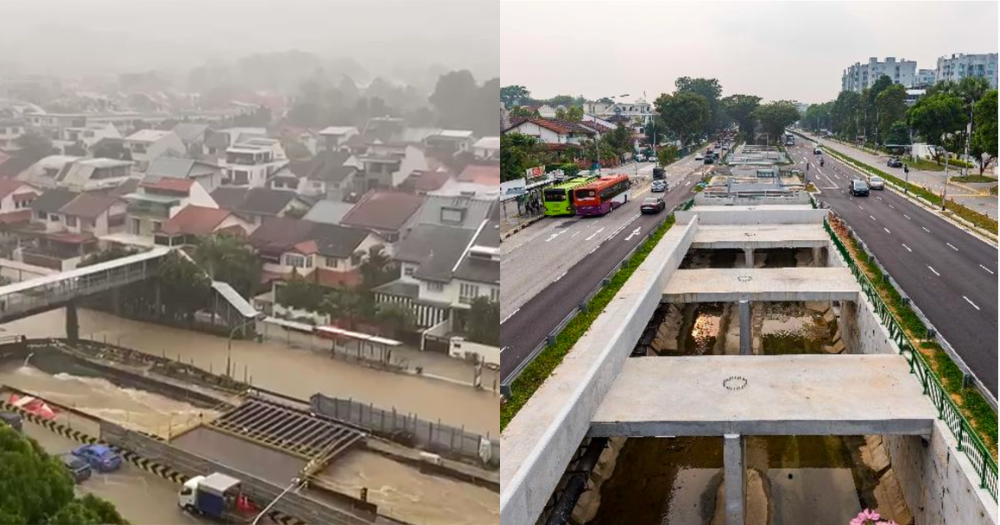
Photo via PUB, SG Traffic Accident/FB


Upgrading works along the entire 2.3km Upper Bukit Timah Canal have been completed following the conclusion of works on its final 900m stretch, allowing the canal to carry 30 per cent more stormwater.
In a media release on Oct. 23, national water agency PUB said the upgraded canal can better cope with rainfall intensities comparable to storms that occurred over the past 15 years.
The improvements will benefit an approximately 1,000-hectare catchment comprising residential areas, commercial developments such as Beauty World Plaza, Bukit Timah Shopping Centre and Dunearn Village, as well as transport nodes like Beauty World and King Albert Park MRT stations.
Upgrading works completed after seven years
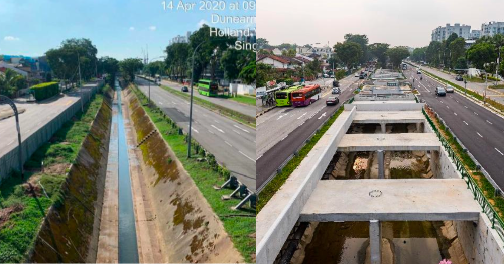 Upper Bukit Timah Canal before (left) and after upgrading works. Photos via PUB.
The final stretch of upgrading works, spanning approximately 900m between Rifle Range Road and Jalan Kampong Chantek, near King Albert Park MRT station, was completed in the third quarter of 2026.
Construction began in October 2019.
The works involved widening and deepening the canal, replacing its trapezoidal design with a U-shaped drain and box culvert to increase its stormwater capacity.
Five box culverts across Bukit Timah Road and Dunearn Road were also upgraded to improve the flow of rainwater from surrounding areas into the canal.
The completed works follow earlier upgrading works along the upstream section between Jalan Jurong Kechil and Rifle Range Road, which were completed in 2024.
According to PUB, the upgrading works faced several challenges, including limited working space between Bukit Timah Road and Dunearn Road.
To minimise disruptions along Bukit Timah Road and Dunearn Road, traffic was progressively diverted and replacement lanes were provided to create temporary working space for the upgrading works.
The works were also coordinated with the planned development of the Bukit Timah–Rochor Green Corridor (BTRGC) in the same area.
According to PUB, the upgrading works between Rifle Range Road and Jalan Kampong Chantek cost approximately S$60 million, including the construction of support structures for the Bukit Timah–Rochor Green Corridor within the canal.
Improved flood resilience, but not flood-proof
PUB's Deputy Chief Executive (Flood Resilience), Angela Koh, described the completion of the upgrading works as an important milestone in strengthening flood resilience in the area.
However, PUB cautioned that the upgraded canal does not eliminate the risk of flooding entirely.
"Given Bukit Timah's topography and land constraints and increasingly intense rainfall due to climate change, very intense storms can still overwhelm the catchment."
History of flooding
Bukit Timah has historically been prone to flooding, with its valley-shaped terrain channeling rainwater into the low-lying canal.
On Apr. 20, 2025, heavy rain caused flash floods in several parts of Bukit Timah, including Bukit Timah Road between Clementi Road and Blackmore Drive, Kings Road and Coronation Walk.
Certain areas experienced ankle-deep floodwaters.
PUB deployed officers to the affected areas, with the situation subsiding by 6:20pm.
The area also experienced flash floods on Aug. 24, 2021, affecting roads including Dunearn Road and Bukit Timah Road near King Albert Park.
Three drainage systems serve Bukit Timah
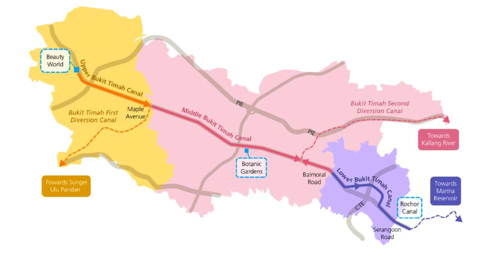 Three drainage systems serving Bukit Timah. Infographic via PUB.
Over the years, PUB has progressively upgraded Bukit Timah's drainage infrastructure to reduce flood risk.
The catchment is now served by three separate drainage systems that direct stormwater towards different waterways.
The approximately 2.3km Upper Bukit Timah Canal, stretching from Beauty World to Maple Avenue, directs rainwater through the Bukit Timah First Diversion Canal (BTFDC) to Sungei Ulu Pandan.
The middle stretch, spanning approximately 5.1km from Maple Avenue to Balmoral Road, channels rainwater through the Bukit Timah Second Diversion Canal (BTSDC) to Kallang River.
Meanwhile, the approximately 2.5km lower stretch from Balmoral Road to Serangoon Road directs stormwater through Rochor Canal to Marina Reservoir.
The first and second diversion canals were completed in 1972 and 1990 respectively, directing stormwater towards Sungei Ulu Pandan and Kallang River.
PUB to study longer-term flood mitigation measures
PUB will call a tender at the end of 2026 for a feasibility study to identify longer-term solutions to strengthen flood resilience across the entire Bukit Timah catchment.
The study will also explore ways to integrate flood mitigation measures with existing infrastructure and future developments, as well as opportunities to enhance public spaces.
"We will continue to improve drainage and raise roads where feasible, while taking a holistic review of the catchment to identify more integrated solutions for the longer term," Koh said.
PUB added that no drainage system can eliminate flood risk entirely and reminded members of the public to remain vigilant during heavy rain.