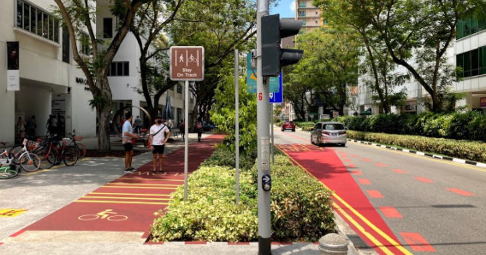
If you’re familiar with the Bras Basah area, you’d know that a major development was the introduction of Bencoolen MRT station along Bencoolen Street.
Bencoolen MRT’s opening meant much greater accessibility for the Bras Basah area.
This came about not just because of the Downtown Line, running deep below street level, but also due to a redesign of the entire street, including a wide, tree-lined footpath and cycling path, additional bike parking facilities, and an all-day bus lane to speed up the commute for those taking public transport.
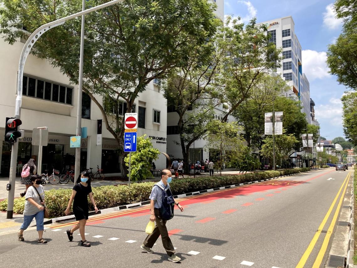 Photo by Nigel Chua.
LTA also collaborated with the Urban Redevelopment Authority (URA) and got students and alumni from NAFA to design the distinctive benches that line Bencoolen Street.
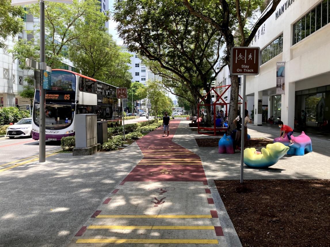 Photo by Nigel Chua.
Further developments to be expected include the Bencoolen Street cycling path being linked up to cycling routes like the ones connecting Queenstown and Bishan to the city, and the planned cycling route along the future North-South Corridor to the Central Business District, which will further improve the connectivity in the area.
Today, looking at Bencoolen Street after the makeover, one might find it hard to believe that the street ever looked any different just five years ago.
What’s going on? Road repurposing.
These changes are just one example of what the Land Transport Authority (LTA) calls “road repurposing”, where — you guessed it — road space is adapted to a different purpose.
Road repurposing is carried out so that bus rides, as well as the walking and cycling experience, can be improved for commuters, while also creating more space for the community.
It is also part of a larger effort to promote Green Transport, that is, transport options that cause less pollution and which do not consume as much natural resources.
This can take the form of walking and cycling, but also includes travel via public transport.
Thanks to the availability of sustainable travel choices, which are made more viable with initiatives like road repurposing, getting around Singapore via Green Transport alone has become more and more convenient over time.
This in turn creates a greener, more sustainable and liveable city
The kind of road repurposing that happened at Bencoolen Street involved part of the road being converted to wider footpaths and cycling paths.
But another type of road repurposing, known as pedestrianisation, involves converting a road fully to a pedestrian pathway, as was the case at Campbell Lane, Albert Mall, and more recently, Armenian Street.
 Campbell Lane in Little India. Photo via LTA.
Since 2019, instead of a road for cars, Armenian Street is now a park, allowing easy access to eateries along the stretch, as well as the Asian Civilisations Museum.
Road repurposing at Kampung Admiralty
Road repurposing doesn’t only happen at downtown sites.
LTA seeks views from residents, businesses and other stakeholders to identify what can be done to improve the road situation, and thus far, over 60 road repurposing projects across various parts of Singapore have been identified, including one near Kampung Admiralty.
If you’ve been around the area recently, you might have noticed that a section of Woodlands Ring Road — between Woodlands Drive 63 and Woodlands Drive 71 — has been closed to cars since February 2021.
Now, those living across the road from Kampung Admiralty can simply stroll across the pathway, instead of having to wait for the traffic lights to change in their favour.
The safety of schoolchildren, and the elderly residents and patients who frequent the area, was just one of the considerations behind the road’s conversion into a footpath.
Other reasons included convenience for pedestrians and public transport commuters, explained transport minister Ong Ye Kung on Facebook.
Not a permanent change…yet
You might notice that the changes at Kampung Admiralty do not look much like the artist’s impression, however, but this is because the changes have yet to be made permanent.
As the road repurposing project impacts the daily lives of Admiralty residents and stakeholders, it is being carried out in two phases. The first phase involves temporary changes being made, so that members of the public can experience them and adapt to.
If the community is supportive, and the project is found to be feasible after Phase 1, the project proceeds to Phase 2, where the changes are implemented permanently.
Kampung Admiralty currently in Phase 1
Therefore, at Kampung Admiralty, where Phase 1 of road repurposing has just started, temporary red and white water-filled barricades now separate the portion of the former three-lane road that has been set aside for pedestrians and cyclists on one side, from a single bus-only lane on the other.
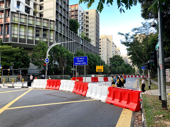 Photo by Nigel Chua.
The community can also engage with LTA to share feedback and suggestions, which helps to ensure that the road changes are able to meet people’s needs.
This allows LTA to take into account the trade-offs involved in road repurposing, and balance the needs of various stakeholders, before proceeding to the next phase of the project.
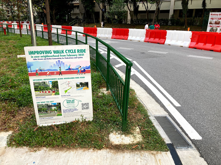 Photo by Nigel Chua.
Road repurposing at Havelock Road
Another recent project at Havelock Road involves reclaiming space used for streetside parking.
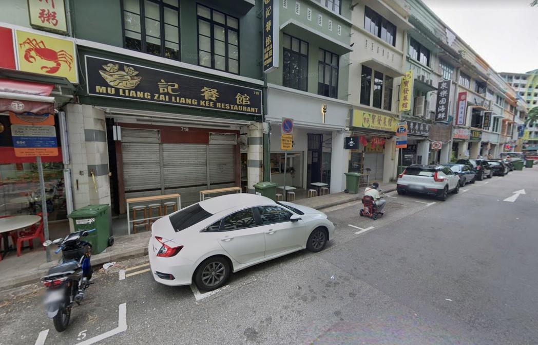 Screenshot via Google Maps street view.
The narrow walkway on the side of the road lined with shophouses was not able to accommodate pedestrian traffic at times, especially during peak hours.
Residents and shop owners in the community had therefore shared their feedback on the situation with LTA, regarding their access to amenities and the general ease of getting around in the area.
LTA, in response to this, launched a trial to convert roadside parking into a wider footpath adjacent to the shophouses.
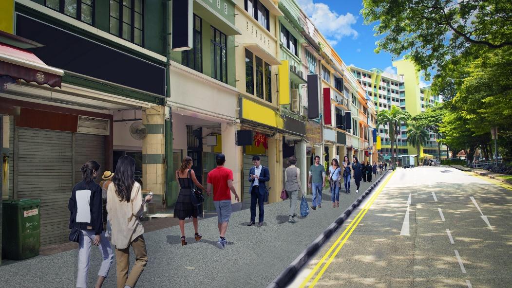 Artist’s impression of Havelock Road after road repurposing. Image via LTA’s website.
After these road repurposing works are completed, the many streetside eateries will be much more easily accessible.
And with parking spaces removed, one imagines that the road will see somewhat less vehicular traffic, making for a safer and more peaceful dining experience for all involved.
Carrying out road repurposing in these two phases means that there is an opportunity to refine the plans before they are made permanent.
As with the Kampung Admiralty project, the residents and shop owners will be able to continue providing feedback on the project as it moves into Phase 1, and before it goes to Phase 2.
It’s not yet certain that all of LTA’s 60 planned road repurposing projects will eventually go through to Phase 2, as this would depend on how the community responds.
One thing’s for sure though — walking or cycling along Bencoolen Street has never been smoother.
This sponsored article by LTA made the author want to go for a ride on his bicycle.
Top photo by Nigel Chua
If you like what you read, follow us on Facebook, Instagram, Twitter and Telegram to get the latest updates.